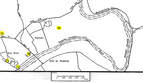
This tour includes the surrounding area of Radford, Virginia. The Surrounding Area Tour has five (5) locations. Each stop is marked on the map by a number. A full description of each stop is shown below with the corresponding number. You can easily use this map in two ways:
Saint Albans School (70)
Located on the present site of St. Albans Hospital, the preparatory boys school was built before the turn of the century. The white brick building facing route 11 is one of the original school buildings.
The present hospital was founded as the St. Albans Sanatorium in 1916, by the late James C. King, who, as superintendent of Southwestern State Hospital in Marion, realized the need for a private psychiatric hospital.
- return to map -
The Town of New River (71)
- return to map -
Union Gun Emplacements (72)
The remains of the earthen readout constructed by the union forces for the bombardment of Radford during the civil war are still visible. The site is often used by the local residents for picnics.
The site can be reached by crossing memorial bridge , taking the first left onto Hazel Hollow road, travel 0.6 miles passing under the railroad trestle and take the first right onto Falling Branch Road, the road divides. Bear right onto Church Street recross the railroad and turn right onto Manns Drive. Continue along Manns Drive and turn into the first driveway on the right. There is a trailer at the end of the drive owned by Mr. James Payne.
Enter the woods to the right halfway between Manns Drive and the trailer. Traveling one hundred feet into the woods one can view the oval remains of the Union redoubt that contained the cannon used to shell the city of Radford.
It is interesting to note that at the battle of Cloyd’s Moutain which preceded the shelling of Radford, two members of the union forces would later become Presidents of the United States.
- return to map -
Sunrise Burial Park (73)
The final resting place of many citizens of Radford
- return to map -
Rockford (74)
The name designated a ford on the New River used as a river crossing. In the years before the inception of the Ingles, Dudley or Pepper's ferry services, the section in Fairlawn, extending from the ford to the Peppers Ferry Road, became known as Rockford. It was also the name which John McCanless Taylor gave to his home.
Taylor, one of the area's earliest residents, owned extensive land on both sides of the New River. Here his daughter, Elizabeth, married Dr. John Blair Radford, on May 31, 1836. As a wedding present, Elizabeth was given 1000 acres of land south of the New River, from Connolly's Run west to Ingles' land.
The site, identified by a local resident, is now an empty lot off route 114, however the location has not been verified.
- return to map -