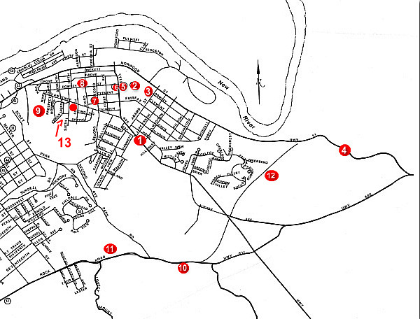
The East Radford Tour has twelve (12) stops. Each stop is marked on the map by a number. A full description of each stop is shown below with the corresponding number. You can easily use this map in two ways:
Halwyck (1)
Located at 915 Tyler Avenue, this is the former home of Governor James Hoge Tyler and his family. The Tyler family moved into the home on April 3, 1891. Bricks for the home were kilned along with those for the Presbyterian Church.
The name Halwyck was given to the home by Governor Tyler's wife, whose ancestors' home in Ireland was named Bally Halwyck, meaning "beautiful home". The three story house has approximately 19 rooms and several windows of colored Victorian glass.
Governor Tyler was active in the business and political affairs of the city, and served as Governor of Virginia from l898 to 1902. He lived in the home until his death in 1925.
- return to map -
Radford University (2)
Founded in 1910 as the State Normal and Industrial School for Women, this became a state teachers college in 1924 and awarded its first bachelor of arts degree in 1935. The first president, Dr. John McConnell, served for 25 years.
In 1964, Radford was authorized to grant the master of science degree. In 1972. after years as a women's college, Radford became coeducational, and in 1979 Radford was granted university status by the General Assembly.
Today, Radford University is an institution which serves more than 9000 students at the undergraduate and graduate levels.
- return to map -
La Belle Inn (3)
Originally located on what is now the Radford University campus, in front of McGuffey Hall and facing Adams Street, this inn was built to house railroad employees.
La Belle Inn was later utilized as Radford's first hospital, Valley View Hospital, and was finally used as a dormitory for Radford College.
The inn was torn down in 1920.
- return to map -
Haven House (4)
Built in the 1790's, this home still stands several hundred feet off Route 11 at the bend in Plum Creek on the Eastern corporate limits of the City of Radford.
- return to map -
Heath's Grove (5)
Heath Grove originally comprised 33 acres in East Radford. On this land the first building at Radford University, Founder's Hall, was built in 1911.
- return to map -
Earliest Area Hospital (6)
Located in Pulaski County, near the Sunrise Cemetery, the first hospital facilities in the area were a temporary arrangement operated for railroad workers.
In 1906, the first hospital was established in the old La Belle Inn (see #3) and was named Valley View Hospital. In 1924, the building now housing the apartments at 306 Tyler Avenue was built to serve as a hospital. The hospital was unsuccessful, and within several years it closed.
Radford was without a hospital for almost fifteen years. A charter was issued for Radford Community Hospital in 1941, and the new hospital was started in the Tyler Avenue building. The building, which could accommodate only 85 patients, proved inadequate.
In 1943, the hospital was moved to its present location at Eighth and Randolph Streets.
- return to map -
First Christian Church
(7)
With approximately 30 members, this Church was organized in 1890. Its first building was dedicated in 1891 on the corner of Fairfax and Second Avenue.
In 1938, the Church, designed by Reverend P. P. Hasselvander, moved into its present home on the corner of Tyler and Clements Streets. A new sanctuary and classrooms were added in 1966, and the library and lounge were renovated in 1983.
- return to map -
Belle Heth Academy (8)
Originally located on the corner of Third and Downey Streets.
- return to map -
Confederate Gun Emplacements
(9)
From this location on the southern slope of Lovely Mount, the Confederate forces occupying the City returned Union fire from Fort Hill on the western bank of the New River on May 10th, 1864.
Arnheim, the home of Dr. John Blair Radford, was located in the line of fire and received damage during this engagement. The engagement lasted four hours and was ended when the Confederate forces ran out of ammunition.
- return to map -
Old Brick Church
(10)
Founded in 1835 by a group of Presbyterians led by Edward Hammet, this was the house of worship for the Radford family. A red brick church was built here in 1840 on land donated by Dr. Radford. It was long known as the Lovely Mount Church.
- return to map -
Lovely Mount Tavern (11)
"On this site a two story log structure was built by John Heavin in 1796 on land purchased from the Trigg family. The 'Lovely Mount Tavern' served as both home for the Heavins and as an inn for travelers on the Wilderness Road.
In time a small settlement grew up around the tavern, including a general store, blacksmith shop and saloon with residences for several families and slave quarters. In 1827 the Heavens moved to southern Indiana, selling the tavern to William Baskerville.
Under Baskerville's management the tavern prospered, and a post office was established there in 1836 with the name Lovely Mount, and with Baskersville as the first postmaster. The post office moved to Ingles Ferry in 1837, returned to Lovely Mount in 1849, and finally to Central City (Radford) in 1888.
In l842 the property was purchased by Dr. John Blair Radford and remained a social and business center of the area until after the Civil War."
- return to map -
Wilderness Road (12)
Also known as the National Turnpike, and locally known as the Ingles Ferry Road, the Wilderness Road in the Radford area can be traced from the State historical marker on Route 11 at its intersection with Route 688.
Today remains of the run along the creek to the right of route 11 as one travels toward Radford. The trail crosses the highway near the Havin House, then courses behind the George Harvey home along the edge of the College Park section and meets Tyler Avenue at the intersection of Tyler Avenue and Auburn Avenue (Route 688). The Trail then courses through the woods behind the Super 8 Motel to Route 611, and passes the Old Brick Church and the Lovely Mount Tavern on its way to the Ingles Ferry.
A major portion of settlers on their way to Kentucky and Tennessee traveled this road. The road was a vital route in the westward movement that continued through most of the nineteenth century.
- return to map -
Central Cemetery (13)
The Central Cemetery is located on Lawrence Street between fourth and sixth Avenue's contains over 30 graves of civil war veterans.
It is said to be the oldest cemetery in Radford. Started by the Roberts family in the area historically known as Central Depot, it contains the graves of many Civil War soldiers and early city residents. Graves of note are Lt. James P. Kelley of the "Immortal 600" and Capt. John T. Howe, both of the famed "Stonewall Brigade". In past years, the graveyard became neglected, but is currently being cared for by Friends of Central Cemetery.
- return to map -
These are the stops in the East Radford Tour. You may click these links to explore the West Radford Tour or the Tour of the Surrounding Area.
- return to top -